Thursday, May 8, 2014

Current Conditions:
Temperature: 69° F
Wind Direction: S at 7 mph
Dew Point: 55° F
Barometric Pressure: 1005.6 mb

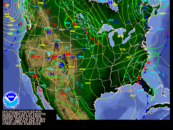
It is starting to feel a little more like summer than spring today in Eau Claire! We currently have a temperature near 70° F but it is still supposed to go up later in the afternoon. It feels very muggy outside and I believe that this is due to the higher dew point. The dew point has been on the rise for the last three days and is currently at 55° F. The clouds have been stratus all day long, and don't show any sign of breaking up at all. We are currently predicted to get severe storms later this evening. There is a low pressure system moving north with a stationary front extended to the south, and a warm front extended to the east from it. There is also a cold front moving in from the north. All of this combining will give our area an increased risk of severe thunderstorms throughout the evening.


Wednesday, May 7, 2014

Current Conditions:
Temperature: 65° F
Wind Direction: SE at 13 mph. Gusts at 24 mph.
Dew Point: 48° F
Barometric Pressure: 1007.7 mb

I think it is safe to say that spring is finally here! Temperatures are in the mid 60's again today with a mild southeast wind. With this southeast wind, it seems as if there will be some precipitation in our near future. We have had periods of sunshine throughout the day, but currently it is more overcast. The clouds appear to be altostratus. There is a large low pressure system system with a warm front moving into our area from the south. This system will bring in warmer temperatures, but it will also bring a chance of rain with it. There is also a cold front moving into the area from the northwest. These two systems will collide sometime tomorrow afternoon which could produce some severe storms. Temperatures are predicted to be in the upper 70's tomorrow which may help to fuel those storms if they do end up forming later in the afternoon.


Tuesday, May 6, 2014

Current Conditions:
Temperature: 61° F
Wind Direction: E at 17 mph. Gusts at 23 mph.
Dew Point: 34° F
Barometric Pressure: 1015.4 mb

It is another great day to be outdoors here in Eau Claire and we should enjoy it while we can! We have temperatures in the mid 60's again today with sunny skies. There are a few clouds in the sky and they appear to be cirrostratus. We currently are seeing strong winds from the east, which typically means we are going to see some form of precipitation in the near future. This belief stands true since we have a great chance of rainfall tonight all the way through Thursday evening. This rain will be caused by the low pressure system and warm front moving in our direction. The low pressure system is predicted to be in eastern Nebraska by Wednesday afternoon, and that will then start impacting the weather conditions here in Eau Claire.


Monday, May 5, 2014

Current Conditions:
Temperature: 61°
Wind Direction: S at 8 mph.
Dew Point: 31° F
Barometric Pressure:1014.9 mb

It has been a beautiful day here in Eau Claire! Currently we have temperatures in the lower 60's and a light south wind. The skies are mostly clear, but the clouds we have seen appear to be cirrus. The sunny skies and lower wind speeds are due to the large dome of high pressure that is currently sitting over most of the upper Midwest. With the south winds we are experiencing, it will help to bring warmer temperatures to the region as we move into Tuesday. It will also bring in more moist air which will help to fuel the storms that we are predicted to see Tuesday evening.


Friday, May 2, 2014

Current Conditions:
Temperature: 50° F
Wind Chill: 46° F
Wind Direction: S at 10 mph.
Dew Point: 40° F
Barometric Pressure: 1006.6 mb

I can home for the weekend, so this weather briefing will be for Plainview, MN. Finally the sun came out today! The morning started off cloudy but now it is partly sunny with a few cumulus clouds in the sky. The winds are out of the south, which is helping to warm the temperatures. This weekend we should have decent weather conditions. The will be an upper level trough moving through the area tomorrow which will cause slightly windier conditions than what we are seeing today. The temperatures should be similar, with about the same amount of cloud cover. Sunday is looking to be a great day. After that trough moves through, there will be large high pressure system moving in behind it. This will bring us sunny skies with very mild wind conditions. It will be a great change compared to what we have seen this last week!


Thursday, May 1, 2014

Current Conditions:
Temperature: 45° F
Wind Chill: 39° F
Wind Direction: NW at 12 mph. Gusts at 18 mph.
Dew Point: 41° F
Barometric Pressure: 1005.7 mb

It is yet another cool and cloudy day here in Eau Claire! Temperatures are still in the mid 40's and it doesn't seem to be changing anytime soon. Our winds are still out of the northwest because that low pressure is passed us and slowly moving its way to the northeast. The center of the low pressure is currently over east central Wisconsin. The clouds that we are seeing appear to be stratus and I believe that is because they are still associated with that low pressure system that has passed. We have had spotty showers throughout the day so far and they will likely continue into Friday. For tomorrow, I believe that we may actually have some sunshine that gets through the clouds as a new air mass moves into the area from the northwest. It is an approaching cold front that will cause a slight chance for precipitation, but it will be nothing like we have seen the last week.


Wednesday, April 30, 2014

Current Conditions:
Temperature: 43°
Wind Chill: 39°
Wind Direction: NW at 7 mph.
Dew Point: 39° F
Barometric Pressure: 1006.0 mb

These cool and cloudy days seem like they are going to be sticking around forever! It is another cool day in Eau Claire with temperatures in the lower 40's. The winds have shifted from an easterly direction and are now coming from the northwest. This shows that the center of the low pressure has passed and is currently located to our southeast. The pressure has been raising slightly, which also means that the system has passed and is starting to move from the area. Given the size of this system, I believe that the clouds will stick around for the rest of the day and most of the day on Thursday as well. For Thursday, I believe we will have similar weather conditions to what we are seeing today. The winds should stay from the northwest, but they may pick up in speed slightly. This is due to the pressure gradient getting greater which is causing the wind speeds to rise. The temperature will stay around the same because there is no warm air being ushered in with the passing of this system.


Tuesday, April 29, 2014

Current Conditions:
Temperature: 40° F
Wind Chill: 34° F
Wind Direction: NE at 10 mph.
Dew Point: 37° F
Barometric Pressure: 1003.0 mb

It is another cool and rainy day here in Eau Claire. We have temperatures hovering around 40° F but the winds are making it feel a like it is a little closer to the freezing mark. Yesterday we had very strong east winds, but they have shifted and are coming out of the NE today. This shows that the center of the low pressure system is currently located to our southwest. This system is moving at a very slow rate is the reason we are experiencing rain for so many consecutive days. After tomorrow, the conditions are will progressively improve. Due to the current location of this system, I believe we will experience more precipitation again tomorrow. In the morning hours, the winds will be from a north eastern direction, but as the day progresses, it will become more of a northwesterly direction. This is caused by the moving low pressure system, as it passes, it will cause the wind directions to shift.


Monday, April 28, 2014

Current Conditions:
Temperatures: 45° F
Wind Chill: 36° F
Wind Direction: E 25 mph. Gusts at 33 mph.
Dew Point: 40° F
Barometric Pressure: 1001.0 mb

There is basically one word that sums up today and that is rain. It has been raining all day long here in Eau Claire. We are experiencing very strong east winds with cloudy skies with what appear to be stratus clouds. There is supposed to be a slight break in the precipitation this evening, but it is predicted to start back up in the early morning hours of Tuesday. All this rainfall is due to a very large low pressure system that is slowly moving its way across the Midwest. It is currently sitting over eastern Nebraska. There is a fairly large pressure gradient with this system that is causing the strong winds that we are experiencing currently. This gradient will not be quite as pronounced tomorrow, and we are expected to have a slight drop in wind speeds. With the slower speed of this system, we have rain again tomorrow for most of the day.


Friday, April 25, 2014

Current Conditions:
Temperature: 63° F
Wind Direction: W at 16 mph. Gusts at 28 mph.
Dew Point: 37° F
Barometric Pressure: 1010.2 mb

I am not in Eau Claire this weekend, so this weather update is for Plainview, MN. It has been a wonderful day to be outside, much different than the weather we experienced yesterday! Temperatures have been in the lower 60's and the skies have been mostly sunny with a few cumulus clouds in the sky. The winds have also picked up since yesterday and I believe that is due to the passing of the low pressure system. This weekend will be a mix for the weather conditions that we will experience. For Saturday, we should have have mainly sunny skies in the morning, but it will gradually become more cloudy as the day progresses. This is due to an approaching low pressure system and stationary front coming from the west. This system will bring rain and windy conditions with it. For Sunday, we will most likely experience cloudy skies all day, with a chance of rain later in the afternoon as the low pressure system gets closer. If you are going to do anything outdoors this weekend, Saturday will be the day to do it! Sunday will be a day to stay indoors!


Thursday, April 24, 2014

Current Conditions:
Temperature: 43° F
Wind Chill: 38° F
Wind Direction: SE at 9 mph.
Dew Point: 41° F
Barometric Pressure: 1007.3 mb

It has been a cold and rainy day here in Eau Claire. I went to bed last night and it was raining, and when I woke up it was still raining! The rain has continued for most of the day but started to lighten up around noon today. We have had overcast skies all day with what appear to be stratus clouds. I believe all this rain is due to a large low pressure system connected to a cold front that is moving across the Midwest. As this system passes, the skies should start to clear up slightly. We may not start to see a break in the clouds until sometime Friday due to the slower speed that this system is moving. For tomorrow, I believe we will see a great change in weather compared to today! Once this rainfall moves out later this evening, we should be in the clear for Friday, in terms of getting precipitation. The wind will most likely shift to the west or northwest due to the passing of the cold front. The skies should start to clear up as the day goes on and the temperatures should be fairly mild as the high is predicted to be in the upper 50's.

Wednesday, April 23, 2014

Current Conditions:
Temperature: 48°
Wind Chill: 43° F
Wind Direction: SE at 13 mph.
Dew Point: 24° F
Barometric Pressure: 1021.1 mb

It is slightly cooler yet again today! It has been overcast most of the day so far with what appear to be stratus clouds. This cloudy trend will likely continue through Thursday and start breaking up towards the end of the week. We currently have strong SE winds bring moist air into the area with a cold front moving our way.


This picture above shows the current surface winds across the country. There is a very defined frontal boundary splitting the country in two. On the east side of the front, there is warm moist air being ushered in from the south. This will be the system that will arrive in our area later tonight and bring the rain that we are expected to see tomorrow.


The picture above shows the amount of water vapor there is in the atmosphere. In front of this system there is a fair amount of moisture. I believe that we will experience rainfall for much of the day tomorrow. With the amount of moisture in the atmosphere, and the speed of the system, I predict it may rain for an extended period of time tomorrow. As the day goes on, the rain should lighten up, but the cloudy skies will stick around for most of Friday.


Tuesday, April 22, 2014

Current Conditions:
Temperature: 52° F
Wind Chill: 48° F
Wind Direction: N at 13 mph. Gusts at 25 mph.
Dew Point: 24° F
Barometric Pressure: 1018.6 mb

It is slightly cooler today than it was yesterday, but it is still a great day to be outdoors! With temperatures in the lower 50's currently, the strong winds from the north make it feel slightly cooler than it really is. The skies are mainly clear with just a few cirrus clouds in the sky. I believe the clear skies and high clouds are due to the large high pressure system that is currently sitting over most of the upper Midwest. For tomorrow I believe we will see a shift in the wind direction. It will probably be more of a southerly flow, and I believe this is due to a low pressure system and warm front that is moving in from the west. As that system approaches, it will bring with it cloudy skies and a great chance for precipitation. It looks to be slower moving, so we may have the next couple of days be cloudy and possibly have some precipitation.


Monday, April 21, 2014

Current Conditions:
Temperature: 58° F
Wind Direction: W at 7 mph.
Dew Point: 55° F
Barometric Pressure: 1012.6 mb

It is finally starting to feel more like spring! When I went to class this morning the temperatures were already 50° F! This weekend turned out to have a lot better weather conditions than I had originally expected. It did not rain as much as I had predicted, a lot of the rain missed Eau Claire this weekend. It is fairly clear outside with a light wind from the west. The clouds appear to be a cirrus as of right now. As the day progresses, the winds will pick up slightly due to the passing of a cold front. As this front passes, there will be a slight chance for precipitation. Once it passes the skies should clear up and the temperatures will drop slightly as a high pressure system moves in from the north. For tomorrow I predict that we will see a very mild day in terms of weather conditions. The sky should be mostly clear with light winds from the west or northwest and temperatures should be somewhere in the mid 50's. As of right now, it looks like those temperatures will stay fairly consistent throughout the rest of the week.

Friday, April 18, 2014

Current Conditions:
Temperature: 50° F
Wind Chill:48° F
Wind Direction: Variable at 5 mph
Dew Point: 20° F
Barometric Pressure: 1028.7 mb

It has been a great day in Eau Claire! After the last couple days with temperatures staying around the freezing mark, it was nice to have a warm up with temperatures around 50° F today! The wind speeds have been very minimal all day which is a change from what it has been the last couple of days. The skies have been mainly clear with only a few cirrus clouds here and there. This weekend we should have very warm conditions compared to last weekend. There is an approaching warm front from the west, and the winds are most likely going to shift to a southerly direction. With the change in wind direction, and an approaching air mass, we should experience fairly warm temperatures. Since this warm front has a cold front coming in right behind it, there will be a potential for precipitation both Saturday and Sunday, with the greatest chance coming on Saturday evening. Other than a slight chance for rainfall, it should be a great weekend to get outside and enjoy the warmer temperatures!


Thursday, April 17, 2014

Current Conditions:
Temperature: 39° F
Wind Chill: 35° F
Wind Direction: NW at 6 mph.
Dew Point: 30° F
Barometric Pressure: 1024.7 mb

It is cooler again today with temperatures hovering around 40° F. The winds have shifted and are currently coming out of the NW. I believe this is due to the passing of a low front, and there is now a new, cooler air mass dominating the region. It has been overcast most of the day with a few breaks in the clouds here and there, but nothing significant. The clouds appear to be cumulostratus because they are large and puffy, but yet cover the entire sky. For tomorrow I predict that we will finally start to see some warmer temperatures. Since it will be cloudy tonight, the clouds will act as insulation and not allow the temperatures to drop quite as low as if it were clear. There is also a warm front approaching from the west. This will most likely cause a shift in wind direction and bring in warmer air.


Wednesday, April 16, 2014

Current Conditions:
Temperature: 35° F
Wind Chill: 25° F
Wind Direction: E at 15 mph. Gusts at 22 mph.
Dew Point: 27° F
Barometric Pressure: 1016.6 mb

Cooler temperatures seems to be the trend so far this week! Once again, the temperatures are hovering just above the freezing mark. The skies have been overcast all day, and I believe this is due to the low pressure system that is moving into the area. Since the wind direction is directly out of the east, I believe that we are right in line with where this system is going to track. Along with it, there will be large amount of precipitation, mainly in the form of snow in the northern parts of Minnesota and Wisconsin.


Above is a picture of just how define this system is. It is having an affect on much of the weather in most of the upper Midwest. Below is a picture showing how much water vapor is in the air. There is a large amount of water vapor over much of northern Minnesota and Wisconsin. This will help fuel all the snowfall that is expected in that area.


For tomorrow I believe we will see cloudy conditions yet again. Depending upon how fast the low pressure system moves from the area will determine how fast the skies will clear up. I believe it will be cloudy for most of the day, but may begin to clear up into the late evening hours. Temperatures may begin to warm up slightly due to an approaching warm front from the west. 

Tuesday, April 15, 2014

Current Conditions:
Temperature: 34° F
Wind Chill: 28° F
Wind Direction: Variable at 7 mph. Gusts at 18 mph.
Dew Point: 5° F
Barometric Pressure: 1019.9 mb

It has been yet another cold day here in Eau Claire! This is due to a trough in the jet stream which has allowed for cold air to drop down over much of the great lakes region. The trough is expected to shift to the east and we should see some warmer temperatures throughout the rest of the week. We have had mainly clear skies with a few cumulus clouds in the sky. These sunny conditions will not last long though. I predict that tomorrow we will see rain/snowy conditions for most of the day. This is due to an approaching low pressure system that is approaching from the west. As the system approaches, it will bring warmer temperatures, but it will also bring wet conditions.


Monday, April 14, 2014

Current Conditions:
Temperature: 35° F
Wind Chill: 25° F
Wind Direction: NW at 16 mph. Gusts at 25 mph.
Dew Point: 13° F
Barometric Pressure: 1016.4 mb

It sure doesn't feel like spring today! I woke up to a snow and ice covered ground this morning! Last night there was a stationary front with a low pressure system that moved through the area. It was unseasonably cold this morning with very strong north winds! It has warmed up slightly as the day has gone on and we are currently just above freezing for our temperature. It has been overcast all day with what appear to be stratus clouds. For tomorrow, I predict we will see temperatures similar to today, but the winds speeds with be significantly lower. This will be due to a strong high pressure system that will be sitting over most of the upper Midwest.

Friday, April 11, 2014

Current Conditions:
Temperature: 48° F
Wind Chill: 44° F
Wind Direction: NE at 8 mph
Dew Point: 40° F
Barometric Pressure: 1015.5 mb

It is another decent day to be outside here in Eau Claire! This morning we had overcast conditions and got it sprinkled a bit around 9:30 this morning. As the day has gone on, the skies have cleared a bit and the clouds currently appear to be fractocumulus. As we approach the evening hours, the skies will begin to cloud up yet again. This is due to an approaching cold front with a low pressure system. As the system approaches it will produce precipitation, and we should see most of that in the morning hours on Saturday. Since it will not completely pass on Saturday, the effects from that front will not be know until Sunday. Temperatures on Saturday are expected to be in the lower 60's again, but on Sunday they are only supposed to be in the upper 40's. This is due to a new air mass moving after that cold front passes. It may be a weekend where staying inside is the best option because it will most likely not be very pleasant outside both Saturday and Sunday.


Thursday, April 10, 2014

Current Conditions:
Temperature: 60° F
Wind Direction: NW at 14 mph. Gusts at 24 mph.
Dew Point: 14° F
Barometric Pressure: 1009.2 mb

It is yet another beautiful day here in Eau Claire! This morning I woke up and we had cooler temperatures and cloudy skies. I believe that to be from the cold front and low pressure system that passed over our area this morning. As the day went on, the winds picked up as the skies cleared and there are currently cirrus clouds in the sky. The rise in wind speed was a direct correlation with the the clearing of the skies and a different air mass moving into the area. For tomorrow, I believe we will see nice weather once again. The temperatures should be in the mid 60's again and the skies should be partly sunny. The winds will probably shift and be coming out of the southwest due the warming temperatures.


Wednesday, April 9, 2014

Current Conditions:
Temperature: 58° F
Wind Direction: S at 9 mph.
Dew Point: 34° F
Barometric Pressure: 1001.5 mb

It has been a great day here in Eau Claire! With temperatures in the mid 60's and mainly clear skies, it was perfect to be outside! The only clouds in the skies appeared to be high level clouds and looked like they were cirrus clouds. The only downfall to the day, was that it was extremely windy day with wind gusts reaching 32 mph! For tomorrow, I believe that we will see weather similar to what we saw today. The skies should not be quite as clear, due to the passing of a cold front and low pressure system. The winds should not be quite as strong, but still fairly strong. It should be very nice temperatures once again tomorrow, as well as through the rest of the week.


Tuesday, April 8, 2014

Current Conditions:
Temperature: 49° F
Wind Chill: 43° F
Wind Direction: N at 15 mph. Gusts at 20 mph.
Dew Point: 31° F
Barometric Pressure: 1012.8 mb

It is great weather here in Eau Claire today! We have temperatures near 50° right now and it may still get slightly warmer throughout the remainder of the day! This morning winds were predominantly coming out of the west, but have since shifted and are currently coming out of the north at 15 mph. We have very clear skies with not a cloud in sight as of right now. This is due to the high pressure system that is currently sitting over most of the Midwest. I believe that tomorrow we will see conditions similar to today, but it will likely be slightly windier with warmer temperatures. The winds are supposed to shift to a more southerly direction, which will bring in warmer temperatures.


Monday, April 7, 2014

Current Conditions:
Temperature:53° F
Wind Chill: 51° F
Wind Direction: W at 7 mph.
Dew Point: 46° F
Barometric Pressure: 1007.0 mb

What beautiful weather we have been having in Eau Claire recently! After all the snow we got on Friday, the weekend was wonderful with sunny skies and warm temperatures and now most, if not all, of that new snow is now melted. Today started with cloudy skies and has gave way to more clear skies into the afternoon hours. We had some showers move through around noon, but it has since cleared and there are some lingering cumulus clouds left in the sky. The wind has been very minimal at 7 mph coming from the west. I believe that we will weather conditions tomorrow that are very similar to today. We should have sunny skies with slower wind speeds with temperatures in the mid 50's. This is due to the high pressure that will be located over much of the western part of the United States.


Friday, April 4, 2014

Current Conditions:
Temperature: 34° F
Wind Chill 22° F
Wind Direction: NW at 21 mph. Gusts at 30 mph.
Dew Point: 29° F
Barometric Pressure: 1008.5 mb

It was feeling more like February than April today! I woke up and realized that it was snowing, and it kept snowing till around 2:30 this afternoon! The temperature is hovering right around freezing so most of the snow is piling up, but a lot of it has turned into a slushy mix. All of this snow fall is due to a large low pressure system moved through well to our south, but still affected our weather conditions. As the system passes through we will have windy conditions until the high pressure system to our west settles over most of the upper Midwest. I believe we will have a very nice weekend in Eau Claire. Once the high pressure moves in, the winds should calm down and the skies should clear up. With an approaching warm front, the temperatures will rise to be in the mid 40's both Saturday and Sunday. The winds should be fairly mild due to the presence of the high pressure system over much of the Midwest.


Thursday, April 3, 2014

Current Conditions:
Temperature: 34° F
Wind Chill: 24° F
Wind Direction: E at 16 mph. Gusts at 24 mph.
Dew Point: 18° F
Barometric Pressure: 1014.6 mb

It is a fairly gloomy day here in Eau Claire. We have had cloudy skies with precipitation on and off throughout most of the day so far. The clouds appear to be stratus. This morning we had a little bit of snow and sleet and right now there is a slight drizzle. Our chance of precipitation continues throughout the day and into the morning hours of Friday. For tomorrow, I predict that we will be seeing a mix of rain and snow for most of the day. There will be a low pressure system that will be moving through the area and that will be the reason for our high chances of precipitation tonight and tomorrow.


Wednesday, April 2, 2014

Current Conditions:
Temperature: 36° F
Wind Chill: 30° F
Wind Direction: NE at 8 mph.
Dew Point: 19° F
Barometric Pressure: 1023.7 mb

It is a beautiful day here in Eau Claire! Although the temperatures are similar to yesterday, the wind is much calmer and it is much sunnier today than it was yesterday! There are a few clouds in the sky and they appear to be cirrostratus clouds. I believe the sunny skies and calmer winds are due to the high pressure that is greatly influencing our weather we are seeing today. Conditions will start to change as we approach the evening hours tonight. It will begin to cloud up tonight and be cloudy for day on Thursday. I believe that this is due to the approaching low pressure system from the south. It will bring with it cloudy skies and a chance for precipitation from this evening through Friday.


Tuesday, April 1, 2014

Current Conditions:
Temperature: 34° F
Wind Chill: 22° F
Wind Direction: W at 22 mph. Gusts at 29 mph
Dew Point: 19° F
Barometric Pressure: 1013.9 mb

It has been unseasonably cold today here in Eau Claire! The temperatures were in the mid 30's but with the wind chill, it felt like it was in the lower 20's. This is due to the cold front that has passed over our area, and there is cooler air from the north moving in with a high pressure system. The day started very windy and with overcast skies. As the day progressed, we encountered a few flurries but the clouds gave way to sunny skies later in the afternoon. I predict that we will have warmer temperatures tomorrow and the winds should slow down slightly. The day will start with clear skies, but as it progresses into the afternoon hours we should start to see clouds moving into our area. This is due to the approaching stationary front from the south. That will be the system that will bring us the precipitation that we are expected to see later in the week.


Monday, March 31, 2014

Current Conditions:
Temperature: 56° F
Wind Direction: SE at 15 mph. Gusts at 26 mph.
Dew Point: 41° F
Barometric Pressure: 999.8 mb

It has been a wonderful day here in Eau Claire! It started off cloudy with some sprinkles early in the day, but there has been some break in the clouds and it is somewhat sunny and warm now! That will not stay for long though as this low pressure system moves closer and passes over our area. It is connected to a cold front, so once that passes, the temperatures will drop slightly.


 It was a beautiful weekend with sunny skies and warmer temperatures. That was due to a southerly wind flow and a warm front that moved our direction. Tomorrow I believe that we will see slightly cooler temperatures due to the passing of that low pressure system. The day will start cloudy as the system will be located over the top of our area. As the day progresses, the skies will gradually clear up and the winds will become stronger. As the picture shows, there will be a fairly large pressure gradient in a short distance which will lead to increased wind speeds.


Friday, March 28, 2014

Current Conditions:
Temperature: 36° F
Wind Chill: 29° F
Wind Direction: NW at 10 mph
Dew Point: 22° F
Barometric Pressure: 1020.4 mb

It is another beautiful day here in Eau Claire. After rain all day yesterday, it is nice to have warm temperatures with sunny skies! The skies have had some cloud cover which appeared to be fractocumulus clouds. The temperatures have stayed fairly steady in the mid 30's and it is only supposed to get warmer over the next couple of days! There is a high pressure system that will be sitting over most of the Midwest for the weekend which will allow us to have sunny skies and the south wind will bring in warmer temperatures. Towards the end of Sunday, a low pressure system will be approaching our area which will bring wetter conditions to our area Monday.


Thursday, March 27, 2014

Current Conditions:
Temperature: 37° F
Wind Chill: 32° F
Wind Direction: E at 7 mph.
Dew Point: 35° F
Barometric Pressure: 999.0 mb

It has been a gloomy day in Eau Claire! When I woke up this morning, it was cloudy and it was starting to mist. It has been precipitating all day long and does not appear to be letting up anytime to soon. The clouds appear to be stratus. The winds have been fairly mild for most of the day with the low pressure system dominating the area.


This system has lots of fuel available which will contribute to the long lasting showers we have had today. As this system passes, clear sunny skies will most likely follow! Since there was a cold front associated with this low pressure, the temperatures will drop slightly tomorrow, but will warm back up going into the weekend.

Wednesday, March 26, 2014

Current Conditions:
Temperature: 34° F
Wind Chill: 24° F
Wind Speed: SE at 15 mph. Gusts at 23 mph.
Dew Point: 18° F
Barometric Pressure: 1011.3 mb

It was slightly warmer today in Eau Claire, but the wind didn't help to make it feel warmer! We had strong SE winds throughout the day! It was slightly cloudy this morning, but began to clear up as the day went on. By midday, the skies were mainly clear with a few clouds that appeared to be cumulus. As sunset approached, the skies were starting to cloud up. I believe that is due to the approaching low pressure system.


Above is a map of the amount of water vapor in the atmosphere. There is a large amount of water vapor over much of Wyoming and the eastern half of South Dakota and Nebraska. I believe this is due to the low pressure system that is currently sitting over that area of the country. We are predicted to get rain for most of the day tomorrow.


I believe we will see a fair amount of precipitation tomorrow. Since there is already a large amount of water vapor in the air and a strong southerly wind will be bringing more moist air to our area, I believe this system will have a lot of fuel to produce precipitation for most of the day.

Tuesday, March 25, 2014

Current Conditions:
Temperature: 17° F
Wind Chill: 2° F
Wind Direction: W at 16 mph. Gusts at 25 mph
Dew Point: 1°
Barometric Pressure: 1024.1 mb

It has been another cold day in Eau Claire! With temperatures well below zero, the wind chill is currently just above 0° F! It has been very windy most of the day which is causing the low wind chills we are seeing today. There were clear skies this morning, but as the day progressed the skies have gradually clouded up with what appears to be cumulostratus clouds. I believe that tomorrow we will see wind speeds similar to today, but may even be a bit stronger. This will be due to the pressure gradient between the high pressure system over us currently and the approaching low pressure system. As the low pressure system moves our way, it will be connected to a warm front and temperatures will most likely rise as a result.


Monday, March 24, 2014

Current Conditions:
Temperature: 25° F
Wind Chill: 18° F
Wind Direction: NW at 6 mph
Dew Point: 22° F
Barometric Pressure: 1021.4 mb

With spring officially being here, hopefully the temperatures start to reflect the change in season! It was a very cool day for March standards with high temperatures only in the mid 20's! As a cold front was passing, the skies were cloudy with what appeared to be altostratus clouds. As the day progressed, the clouds seemed to get lower and thicker and it then began to snow around 1:30 this afternoon. The snow totals ended up only being a slight dusting. I believe that tomorrow we will see cooler temperatures due to the cold front that passed over us with a high pressure following. Due to the high pressure system, we will probably see mostly sunny skies for most of the day.


Friday, March 14, 2014

Current Conditions:
Temperature: 36°F
Wind Chill: 26° F
Wind Direction: NW at 17 mph
Dew Point: 29° F
Barometric Pressure: 1003.2 mb

With the starting of spring break, I was able to come home yesterday evening. Since I am not in the Eau Claire, this weather prediction will be for Plainview, MN. The winds have switched direction with the passing of a cold front, and they are currently coming out the northwest close to 20 mph. The skies are fairly clear with a few cumulus humilis clouds in the sky. The skies should progressively get cloudier as the day goes on with another approaching cold front.


This weekend should be fairly mild. With the approaching cold front, there will be a slight chance for some snow showers on Saturday, but it should not amount to much if it does snow. The skies should be cloudy most of Saturday, but clear up into Sunday. Temperatures will be slightly lower Sunday than Saturday due to the passing cold front. It is then projected to warm up into the mid 30's again at the beginning of next week

Thursday, March 13, 2014

Current Conditions:
Temperature: 42° F
Wind Chill: 35° F
Wind Direction: SW at 14 mph.
Dew Point: 29° F
Barometric Pressure: 1007.4 mb

It is another great day to be outdoors in Eau Claire! The temperatures are in the lower 40's and are supposed to stay there into Friday. The skies were clear today with winds coming from the southwest. That is helping to usher in the warmer air that we are seeing today.


I believe that tomorrow we will have similar temperatures as to what we have today. It will be most likely be cloudy since there will be a low pressure system moving east and it will be just to our north. There are two cold fronts connected with that pressure system. This will likely lead to a change in wind direction and a clearing of the skies as the fronts pass.


Wednesday, March 12, 2014

Current Conditions:
Temperature: 24° F
Wind Chill: 14° F
Wind Direction: NW at 9 mph
Dew Point: 7° F
Barometric Pressure: 1019.4 mb

It is not as warm as yesterday, but still a very pleasant day in Eau Claire. On my way to class this morning, we had fairly cloudy skies with what looked like cirrostratus clouds. As the day progressed, the skies gradually cleared and we are currently experiencing very sunny conditions. I believe this is due to a high pressure that is establishing itself over the upper Midwest. There is a warm front that will be moving into the area tomorrow and will help to raise the temperatures into the 40's once again. I believe that tomorrow we will experience a warm up in temperature and a see a few more clouds due to a warm front moving our way. The winds will probably shift to a more southwesterly direction and bring in some warmer air.


Tuesday, March 11, 2014

Current Conditions:
Temperature: 36° F
Wind Chill: 29° F
Wind Direction: N at 10 mph. Gusts at 20 mph.
Dew Point: 20° F
Barometric Pressure: 1013.5 mb

Slowly but surely it is starting to feel more and more like spring. Temperatures were in the upper 30's most of the day with overcast skies covered by what looked like altocumulus clouds. We did not get any rain in Eau Claire, but there was rainfall in southwest Wisconsin and southeastern Minnesota. Tomorrow we will have a slight drop in temperatures, but it should warm up again towards the end of the week. Since the stationary front has passed and their is a high pressure system moving in, that is contributing to our colder temperatures tomorrow. It should not last long though with a warm front moving in from the north that should reach our area sometime Thursday.


Monday, March 10, 2014

Current Conditions:
Temperature: 49° F
Wind Chill: 44° F
Wind Direction: W at 13 mph
Dew Point: 33° F
Barometric Pressure: 1003.2 mb

It is absolutely fantastic outside today! Sunny skies with temperatures near 50° F are much needed after all the cold we have experienced this winter! There have been some clouds in the area today. I believe they are cirrus clouds since they appear to be very high in the sky and have a wispy look to them.


We have very stable air conditions today with an LI index of 11.6. This makes sense due to the current weather conditions we are seeing with high wispy clouds with a slight west wind. Tomorrow I believe we will see slightly different weather conditions. There will be a stationary front that will be moving across the country that will impact our weather tomorrow. It will bring in cloudy skies most of the day, and with that there will be a slight chance for precipitation most of the day. It shouldn't amount to much if it does rain or snow. The temperatures are predicted to drop into the mid 30's for a high tomorrow and I believe that is due to a cold front that will be moving across our area throughout the evening hours tonight.


Friday, March 7, 2014

Current Conditions:
Temperature: 33° F
Wind Chill: 24° F
Wind Direction: N at 12 mph
Dew Point: 27° F
Barometric Pressure: 1014.0 mb

It is a been a fantastic day in Eau Claire! Temperatures were above the freezing point for most of the day, and it is helping to slowly melt all the snow that we have. It has been cloudy most of the day with the skies covered in what appeared stratus clouds. The conditions stayed consistent through most of the day due to the low pressure system that has been influencing our conditions today. As the night goes on the low pressure and cold front that is connected to it will be moving over most of the upper Midwest.


This illustration shows where the different fronts are located across the country. I believe that because of where these different systems are located, we should have very great weather this weekend. There will be a high pressure system that will be moving into the area which will bring clear skies and mild wind speeds. Since a cold front passed, I believe that it will be slightly cooler tomorrow than it was today. Then it should start warming up into Sunday. The skies should be mostly clear all weekend and early into next week.

Thursday, March 6, 2014

Current Conditions:
Temperature: 27° F
Wind Chill: 16° F
Wind Direction: S at 13 mph. Gusts at 22 mph.
Dew Point: 16° F
Barometric Pressure: 1020.0 mb

Other than very strong winds, it was a another beautiful day in Eau Claire! The day started off cold and cloudy, but got better as the day went on. In the afternoon, the skies began to clear up, and by the evening hours we had a few cirrus clouds in the area.


This graphic shows how most of the Midwest had clear skies with a south wind. Where the skies start clouding up is around the low pressure system with the warm front that is approaching our area. The south winds that we are experiencing are helping to bring warmer temperatures to our area. I believe that tomorrow we will see warmer conditions as well as a chance for some snow and freezing rain.

Wednesday, March 5, 2014

Current Conditions:
Temperature: 19° F
Wind Chill: 6° F
Wind Direction: NE at 13 mph
Dew Point: 6° F
Barometric Pressure: 1033.2 mb

It is finally starting to feel like spring! It is sunny today with temperatures around 20° F and it is predicted to get a little warmer throughout the remainder of the day! There is a high pressure system north of the Great Lakes which is causing the clear skies we are seeing today. We have very stable weather conditions, with a very low KI index and very high LI index.


I predict that tomorrow we will see conditions similar to today. There is a warm front approaching our area from the West which have an impact on our temperatures tomorrow, as we are predicted to reach 31° F! With that approaching front, I believe the winds will shift to a more southerly direction as compared to today. As the front approaches, the skies should begin to cloud up as well as the wind speeds.


Tuesday, March 4, 2014

Current Conditions:
Temperature: 16° F
Wind Chill: 7° F
Wind Direction: E at 6 mph
Dew Point: 5° F
Barometric Pressure: 1023.6 mb

Well, with the closing of winter by meteorological standards, we have had the coldest winter in recorded history in Eau Claire! Unfortunately winter doesn't stop by meteorological standards, and we may still have a few more weeks with snow in the forecast.


That being said, we have had a slight warm up today, and it is expected to continue to warm as the week progresses. Today we have had nice temperatures with a high near 20° F with overcast skies. I predict that tomorrow we will see much of the same conditions that we have seen so far today. The main difference would be that the skies should start to clear up as the day goes on. There will be a high pressure to the north that will be influencing the weather conditions that we will be seeing.

Monday, March 3, 2014

Current Conditions:
Temperature: 6° F
Wind Direction: W at 3 mph
Dew Point: -10° F
Barometric Pressure: 1033.9 mb

March arrived this weekend and brought more very cold and windy conditions with it. High temperatures were only in the single digits and that is about 25° F below the average temperature for this time of year! Today isn't much different, with the current temperature at 6° F and with a predicted high temperature of 12° F. It has been overcast for most of the day with a slight wind from the west. Tonight there is a slight chance of snow and Eau Claire is only predicted to get 1-2 inches total. Tomorrow I predict that we will have similar conditions to what we are seeing today. Once the snow moves through, the skies should stay mainly over cast, but it may be slightly warmer than it is today. The winds should be fairly mild as well since there is no great change in pressure systems.